Laddar...
Germany

Landscape

Orthophoto Scenery Hamburg

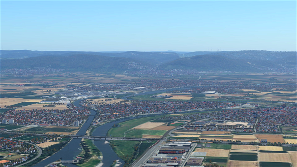
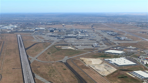
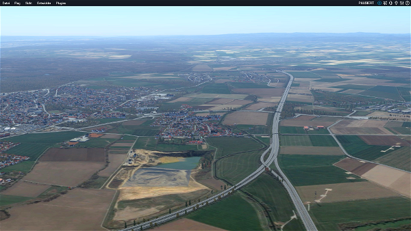
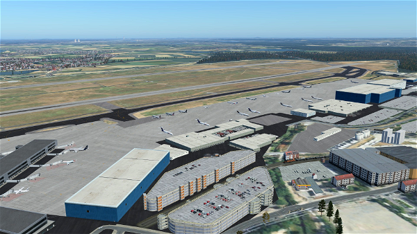
Moin, Ich habe mich mal ein wenig mit Ortho4XP beschäftigt um etwas neuere Tapete zu erhalten, ich nutze hier in diesem Fall unterschiedliche Aufnahmen, was natürlich zu etwaigen farblichen Abweichungen kommen kann. Ich habe ebenfalls unterschiedliche Zoomlevel verwendet, von ZL 16 bis ZL 17 in...

Om

Moin,

Ich habe mich mal ein wenig mit Ortho4XP beschäftigt um etwas neuere Tapete zu erhalten, ich nutze hier in diesem Fall unterschiedliche Aufnahmen,

was natürlich zu etwaigen farblichen Abweichungen kommen kann. Ich habe ebenfalls unterschiedliche Zoomlevel verwendet, von ZL 16 bis ZL 17 in Flughafennähe ZL 18.

Ich fliege zu 98% nur Airlines,, da genügt mir die Auflösung. Außerdem nimmt es sonst zu viel Platz weg.

Falls interesse daran besteht, ich habe dadurch schon einen großteil von Europa abgedeckt. Sollten bessere Bilddaten vorhanden sein, werden diese ersetzt.

Installation:

Die Datei in das X-Plane Custom Scenery Verzeichnis setzen und in der Scenery.packs auf die richtige Position setzen.

-------------------------------------------------------------------------

Beispiel (Scenery.packs):

Global Airports

Europe X

libraries

zzz_orthophotos (hier gehört die aktiviert hin)

zzz_mesh

--------------------------------------------------------------------------

Achtung: Es sollte nur in Verbindung mit Simheavens X World Europa verwendet werden: https://simheaven.com/xp12-sceneries/

da ich leider noch nicht weiß wie ich die Overlays mit hinzufüge.

Wichtig!!!

Für die Nutzung ohne Simheavens X World Europe, wird diese Overlay Datei benötigt.

https://de.x-plane.to/file/211/orthophoto-overlays-important-for-the-orthophotos

Important!!!


For use without Simheavens X World Europe, this overlay file is required.


https://de.x-plane.to/file/211/orthophoto-overlays-important-for-the-orthophotos

Außerdem ist X-Europe eh ein must have für X-Plane, da er gewaltig aufgewertet wird und es ist freeware.

Ohne schaut man sonst nur auf eine nackte Tapete.

Großen Dank und ein riesen Respekt an den Entwickler.

Ebenfalls geht mein Dank an den Entwicker von dem Ortho4XP tool.

Sollte interesse bestehen werde ich auch gerne weitere Tiles hochladen, ich selber habe Mitteleuropa mittlerweile abgedeckt.

Viel Spaß :-)

Details
Kompatibilitet
Kategori
Landscape
Första lanseringen
September 28, 2022
Senast uppdaterad
2 year(s) ago — 1.0

Version

1.0

Filstorlek

2.44 GB

Downloads

443

Information om filen

Prenumeranter
6
Betyg
0/5.0 — Okänd
Status
Inte nedladdad ännu
Dagens nedladdningar
1
Koordinater
+53+009

Okänd
Baserat på 0 betygsättning
😢
0
ledsen
😠
0
arg
😮
0
chockad
🙏
0
tacksam
😂
0
road
😍
0
kärleksfull

Timeline

  • Initial File Release


Behörigheter

Tillstånd för uppladdning
Du får inte ladda upp denna fil till andra webbplatser under några omständigheter.

Tillstånd till ändring
Du får inte ändra eller förbättra min fil under några omständigheter.

Tillstånd för ombyggnad
Det är inte tillåtet att konvertera denna fil under några omständigheter.

Tillstånd för användning av tillgångar
Du får använda tillgångar i min fil utan tillstånd eller krediter.

© chrima83 - All rights reserved. Det är förbjudet att ladda upp eller distribuera denna fil på nytt utan upphovsmannens skriftliga medgivande. Denna Flight Simulator 2020 Mod skapades av chrima83 and shared in Scenery Enhancements » Landscape för X-Plane 12.


0 Kommentarer

Bli den första att kommentera.


Roadmap
Dessa artiklar finns för närvarande på listan och kommer att behandlas inom kort!
Backlog
Förslag, fel och idéer för framtiden.

  • Lanserad September 28, 2022

    Den första versionen av denna fil har just lanserats. Välkommen ombord!

Vanliga frågor

Frågor? Hitta din lösning här.


Det är ganska tomt här borta.

Donationer

Dessa användare har donerat till chrima83 så att han kan fortsätta att göra fantastiska tillägg som alla kan njuta av.

Beroenden

These add-ons may be required or recommended to use.


Det är ganska tomt här borta.


Google Maps Import

Parts of this content includes 3D data and textures copyrighted by « Google Map data ». Google Maps and Map data are provided by © Google, LLC, Mountain View, California, US. This free creation contains content from Google Maps or Google Earth, in accordance with Google Terms of Services and especially point 2.2 of Google Maps/Google Earth Additional Terms of Service. This creation is based on « fair use » or « fair dealing » of the data provided by Google through its services. No commercial use or any gain will be made by the author of this creation or the original host site, who use Google assets as provided for by the simple user licence. The author is freely sharing a creative application of Google Maps or Google Earth. The author will not receive any form of remuneration for sharing this work. Spontaneous general donations from users of file hosting web services under the form of « rewards » or « tips » will be rejected. If this content is found elsewhere and is offered in exchange of money or any other kind of remuneration, it is without the permission of the author and if such theft of intellectual property occurs, this site, and the author will disavow such distribution. Google has stated that it cannot answer to any direct demand about a particular creative use of its properties, as it stated in the « written permission » paragraph of the same document, and all such demands should in the first instance be directed to the author of this work. The author’s verification of compliance with Google’s Terms of Services will rest on this statement of intent, and the use of the provision of the « Fair use » paragraph of the document. As it is economically unreasonable for the casual creator of this content to ask for a costly legal analysis of its creation like proposed in the « Fair use » paragraph of the document, the author of this creation and the owners of this site undertake to destroy any trace of the work on first demand from Google, in accordance with the paragraph « Taking action in case of problems » of the Google Terms of Service about « advance notice » provided « when reasonably possible ».